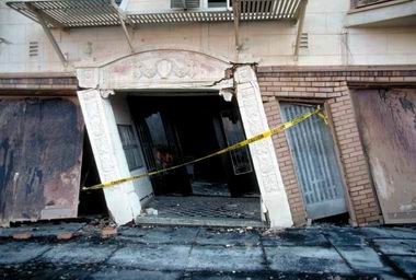
Assuming we spend an average 40-60% of time in our home (including sleeping), whatever place we decide to call home should be looked at from all angles of safety. This is especially true in the Bay Area, where there's a 63% probability of a major earthquake in the next 30 years (from the USGS earthquake probability site).
This is not meant to scare anyone, but rather to make everyone aware of the real risks that exist when living in San Francisco. This education should help you make an informed decision on you and your family's safety. I created the maps shown below to highlight the various safety concerns by location, and used data compiled mostly from government websites. These maps are a high-level summary, and aren't intended to provide a thorough or comprehensive look at the data. For deeper research, please follow the captioned links which bring you to the source data.
Landfill
The first consideration is whether the home is built over a landfill. Because landfill contents are more likely to shift and compact during an earthquake, they aren't as structurally safe as homes built on bedrock. When this soft soil starts moving during an earthquake, it becomes like quicksand (known as liquefaction), and can shift the structural integrity of the building. Besides damaging the building, it can also lead to water/gas pipes bursting.
Here's a map I created using data from the USGS site, showing areas at liquefaction risk in the event of a major earthquake:
 |
| Data compiled from USGS Liquefaction site |
Non-retrofitted buildings
Several years ago, San Francisco's Department of Building Inspection made a preliminary list of buildings that might be structurally unsound in the event of an earthquake. This was done with a basic street-view inspection, so the numbers are not confirmed. But the investigation flagged a potential 2,929 houses that are possibly unfit to survive a disaster (see listings by address here).
 |
| Image from Bay Area Structural Engineers |
One risk in particular are what's known as "soft-story buildings". This is when the building has a garage on the ground level. Even though it is built to withstand the building's weight, these levels are still not as structurally sound in an earthquake.
Here's a map of data from the SF Public Press site, where they showed all addresses listed from the inspection:
 |
| Data compiled from the SF Public Press website |
Tsunami
In the aftermath of an earthquake, there's some risk of a tsunami coming in from the Pacific Ocean. This risk is mostly for perimeter areas of San Francisco, as you can see in this map of data from the State of California's Department of Conservation:
 |
| Data compiled from the Department of Conservation website |
Crime
Besides the risks associated with a natural disaster, there's also the day-to-day risks associated with living in a high crime area. The website Trulia has created an interactive map of high crime areas, and I've compiled that data into this map:
 |
| Data compiled from www.trulia.com |
Or, you can always check the crime safety of your neighborhood by seeing if Amici's Pizza delivers there.
 |
| Map available at www.amicis.com |
Destruction in Films
And since art imitates life, we can also analyze the San Francisco hazard areas that have been destroyed in various Hollywood films (most famously of course is the Golden Gate Bridge, which for some reason filmmakers love destroying in movies). This map is just for fun:
 |
| Data compiled from SF Gate article |
Summary
When all is said and done, we can combine these maps together and get a hideously ugly map of bright colors. Based on the criteria we've outlined, anything you see in yellow below would be considered a lower risk area. Initial analysis would show the safest areas seem to be the Presidio, Cole Valley, and Inner Sunset neighborhoods.
 | ||
| Compilation map of all data shown in this site (created by The Big Social Picture) |
Additional Resources
- The most useful thing you can do for you and your family is get educated. Did you know there's a free San Francisco training course taught by the fire department? It's all about being prepared in an earthquake, and it will give you the choice to help others as well. Find out more at the NERT website.
- I wrote a post about what I learned from NERT training. Check it out here for tips on what to do before, during, and after an emergency.
- San Francisco also offers an alert-based text service called AlertSF. You can sign up for text message notifications which can help you avoid certain areas of the city.
- Follow @Emergency_In_SF on Twitter for updates as well.
- Want to see a more thorough breakdown of your location? Check out this interactive search page (thanks Redditor brendapie!)
And again, I hope this is the most helpful information you never have to use.


